Severn River
Chart of the Severn River
Find other maps and charts here
Discover the Severn River Chart
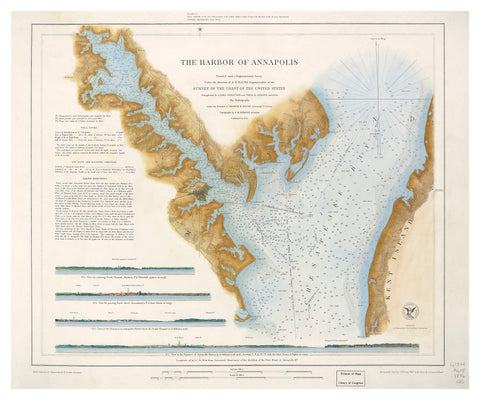
The Severn River is an iconic waterway in Maryland. This detailed chart captures the rich geography of the Severn River as it winds through beautiful landscapes near Annapolis. The illustration blends artistry and accuracy, making it a unique addition to any home, office, or marine space. Whether you are passionate about boating or love historical maps, this chart brings the Severn River to life.
Each feature on this map is carefully labeled. You will notice well-known creeks, inlets, and points along the shore. The chart also highlights neighboring rivers, showing how the Severn fits into the larger Chesapeake Bay region. This makes it a valuable resource for both navigation and education.
Features of the Severn River Chart
- Highly Detailed Illustration: Every curve of the river and branch of the watershed is shown. The chart not only covers the main waterway but also smaller tributaries.
- Historic and Artistic Value: With hand-drawn features, the chart offers a sense of nostalgia. It also includes a decorative compass rose and nautical elements.
- Perfect for Various Spaces: This chart makes a striking wall display. It is wonderful for offices, living rooms, studies, and even marine clubs.
- Educational Tool: Teachers, students, and historians can use this map to understand local geography and history.
- Ideal Gift: The chart is an excellent gift for anyone who loves Maryland, sailing, or cartography.
About the Severn River
The Severn River runs through Anne Arundel County, ending near the city of Annapolis. Its winding shape is home to many coves, marinas, and waterfront communities. Boaters, kayakers, and paddleboarders frequent the calm waters. The river is also a habitat for local wildlife.
Chesapeake Bay influences the area’s maritime culture. Fishing, sailing, and exploring have been part of life here for generations. This chart helps connect you to that wonderful legacy.
Why Choose This Chart?
- Quality and Accuracy: The map was produced by the Severn River Association. It is based on careful research and historical data.
- Artisan Appeal: Each detail is meticulously illustrated to balance function and beauty.
- Ready to Frame: The sizing allows easy framing, so you can display the map immediately.
Related Charts and Maps
If you enjoy collecting maps, there are many other options available. Find other maps and charts here to explore more nautical and regional charts. Our collection ranges from historic harbor charts to contemporary artwork inspired by Maryland’s waterways.
Each map in our gallery aims to showcase the beauty, wonder, and intricate detail that set this region apart. You might discover other rivers, coastal areas, or artistic interpretations to complement your Severn River map.
Find other maps and charts here to continue your journey!